Infraland and Boultbee Brooks Renewable Energy are proposing to develop a new solar farm to be known as Tiddiecross Solar Farm.
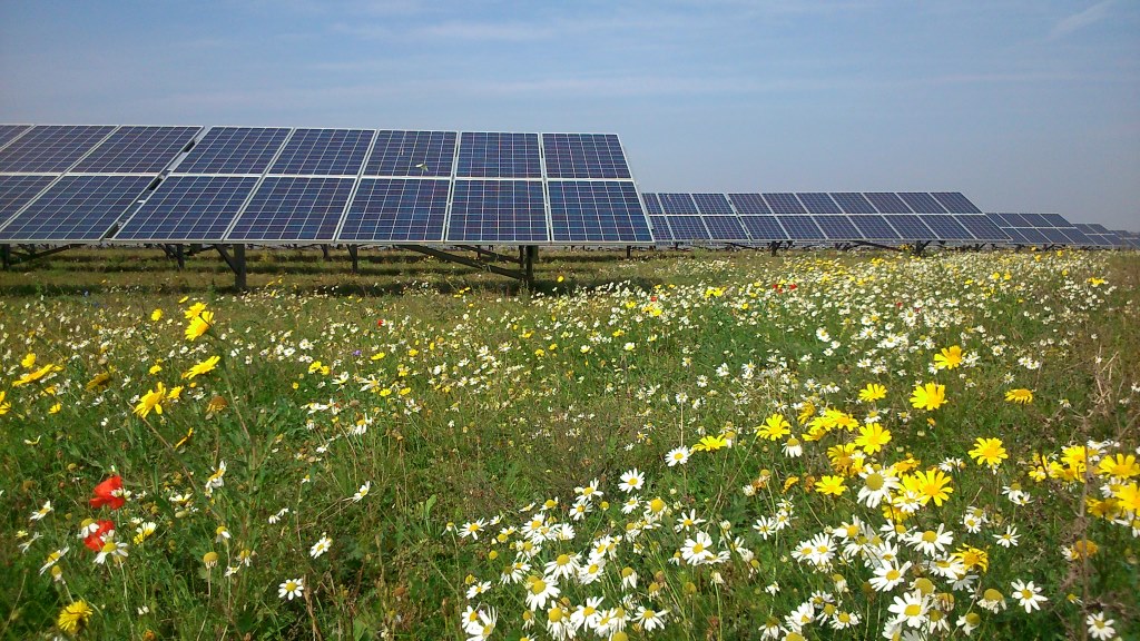
The transition to a low carbon energy system is necessary to avoid the catastrophic effects of climate change. The UK’s legal climate change commitment requires achieving net-zero greenhouse gas emissions by 2050 and more renewable energy generation is needed to meet this target. Solar farms offer a low cost and safe form of renewable energy generation. Solar powered electricity reduces the levels of carbon dioxide that are being emitted into the atmosphere by replacing the demand on electricity generation from fossil fuels. The temporary ‘rewilding’ of the land, through the provision of species rich grassland beneath and around the panels within a solar farm and the delivery of new boundary landscaping, results in considerable increases in biodiversity and provides new habitats for wildlife. It also allows the land to rest, which can improve the quality of the soil.
Infraland and Boultbee Brooks Renewable Energy are working together to develop a new portfolio of efficient and biodiverse solar farms across the UK. The partnership is led by individuals with over 70 years of combined experience in clean energy and sustainable development projects in the UK and Europe. We are now harnessing that experience to contribute to the UK’s net zero 2050 carbon target. We are also committed to achieving biodiversity enhancements in and around the projects we work on by sensitively assessing and supplementing existing habitats.

Infraland and Boultbee Brooks Renewable Energy are working together to develop a new portfolio of efficient and biodiverse solar farms across the UK. The partnership is led by individuals with over 70 years of combined experience in clean energy and sustainable development projects in the UK and Europe. We are now harnessing that experience to contribute to the UK’s net zero 2050 carbon target. We are also committed to achieving biodiversity enhancements in and around the projects we work on by sensitively assessing and supplementing existing habitats.
This site was carefully selected to ensure that it met with technical and environmental criteria, including a viable grid connection nearby which is capable of accepting the power generated. Being free from statutory environmental and historic designations, along with the topography, low agricultural land grade, limited flood risk potential and the presence of vegetation along the site’s boundaries that provide natural screening, were all factors in choosing this location.


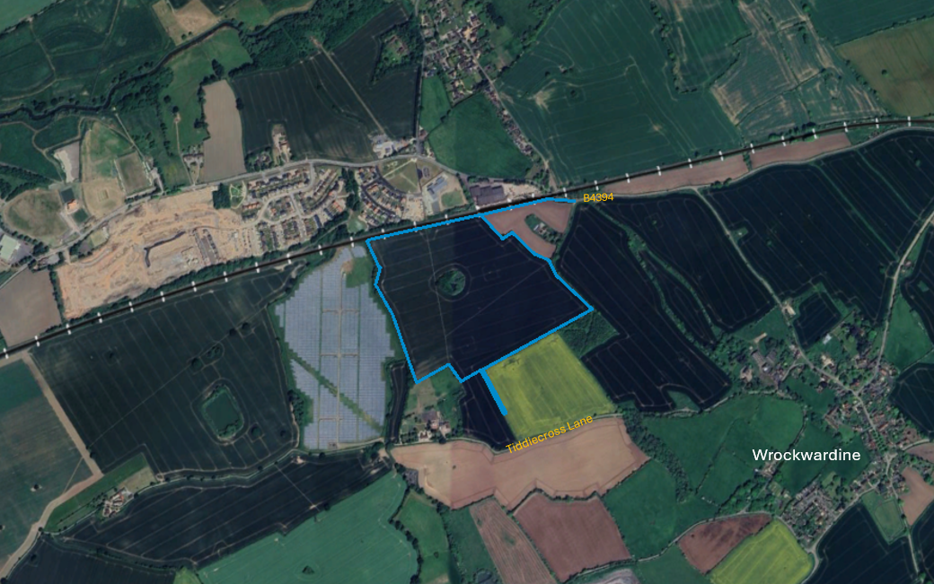
- The site is located on land circa 400m to the north-west of the village of Wrockwardine, which is itself circa 1km to the west of the urban area of Telford.
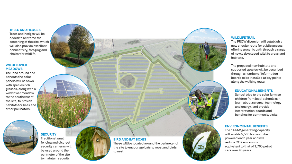
- The solar farm will have a generating capacity of circa 14 megawatts (MW) of renewable energy.
- The proposed solar farm, together with the proposed new landscaping, below ground cable and access route cover an area of circa 19.76 hectares (49 acres).
- The solar farm will be operational for a period of up to 40 years, after which the modules would be decommissioned and removed from the site and as many items as possible will be recycled or re-purposed with the site returned to farmland.
- The development will connect to the National Grid Electricity Distribution network via a new underground cable to an existing pylon located on the existing overheard 33kv line which lies to the immediate south of the site.
- The site sits predominantly on lower quality grade 3b land which is not considered to be best and most versatile agricultural land as set out in the National Planning Policy Framework.

- The site is located on land circa 400m to the north-west of the village of Wrockwardine, which is itself circa 1km to the west of the urban area of Telford.
- The solar farm will have a generating capacity of circa 14 megawatts (MW) of renewable energy.
- The proposed solar farm, together with the proposed new landscaping, below ground cable and access route cover an area of circa 19.76 hectares (49 acres).
- The solar farm will be operational for a period of up to 40 years, after which the modules would be decommissioned and removed from the site and as many items as possible will be recycled or re-purposed with the site returned to farmland.
- The development will connect to the National Grid Electricity Distribution network via a new underground cable to an existing pylon located on the existing overheard 33kv line which lies to the immediate south of the site.
- The site sits predominantly on lower quality grade 3b land which is not considered to be best and most versatile agricultural land as set out in the National Planning Policy Framework.
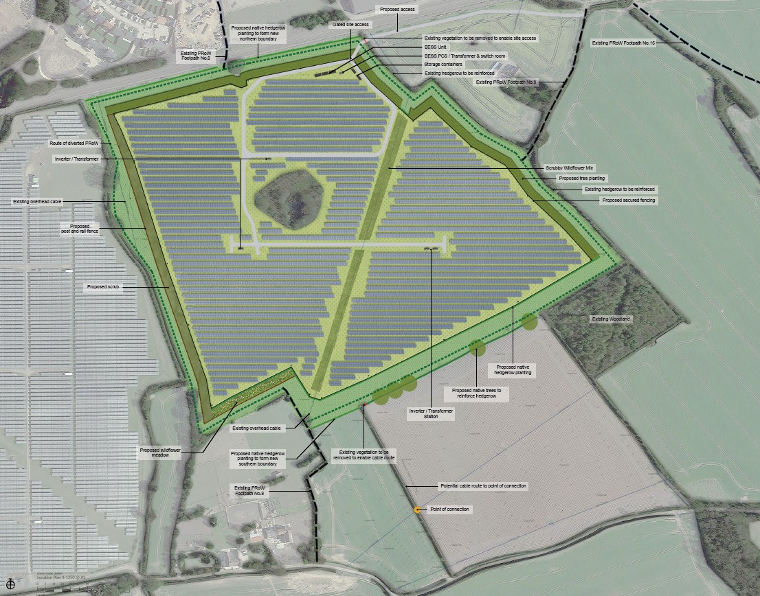
We have prepared the site layout shown on this page. The design of our proposals respond, where appropriate, to technical studies and consultation feedback received to date.
All of our solar farms include minimum separation distances between solar panels of 3m. Biodiversity enhancements such as pasture-mix grassland and wildflower seed mix planting can be implemented between the panels.
- The development would consist of static rows of photovoltaic (PV) solar panels fixed onto a metal framework supported by either single or double mounted posts, together with supporting infrastructure, including battery energy storage system units, inverters and transformers (to be housed in cabinets), a customer substation, and a storage container, access, boundary fencing and new landscaping.
- The panels would be set to a maximum height of 3m.
- The metal posts would be pile-driven into the ground.
- The panels would be laid out in straight rows west to east across the field set at vertical angle of between 20 and 25 degrees.
- The final number of panels depends on a variety of factors such as the capacity of each panel and the design of the rows of panels.
- None of the on-site infrastructure cabinets are to be greater than 4m tall.
- The site will have a perimeter wide paladin fence with a height of 2.4m, as well as CCTV cameras facing into the site. There would be no need for floodlighting.
- Existing boundary hedgerows will be maintained and reinforced where needed and new areas of meadow and tree planting are proposed on the boundaries of the site.
- The existing Public Right of Way (PRoW) which directly crosses the site will be diverted around the perimeter of the site, to provide a new circular walking route set within new wildlife habitats.
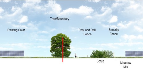
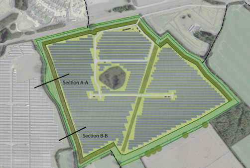
Site sections have been created to provide a visual representation of how the development will appear upon completion. These illustrations offer an insight into the layout, showcasing key features, including landscaping, new circular PROW, wildlife areas and habitats and the proposed infrastructure. The sections demonstrate that the development will integrate with the existing environment and will offer a number of environmental benefits.
Section A-A

Section B-B
Site sections have been created to provide a visual representation of how the development will appear upon completion. These illustrations offer an insight into the layout, showcasing key features, including landscaping, new circular PROW, wildlife areas and habitats and the proposed infrastructure. The sections demonstrate that the development will integrate with the existing environment and will offer a number of environmental benefits.
Section A-A
Section B-B
The proposals will deliver notable benefits including:
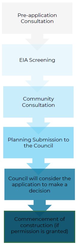
The Planning Process
We intend to submit a full planning application to Telford and Wrekin Council once we have reviewed the responses received to this consultation and made any required updates to the proposed design.
The proposed design has sought to respond to the recommendations of a number of technical assessments which are ongoing and include the following:
Landscape and Visual Impact
A Landscape and Visual Impact Assessment (LVIA) is being undertaken in accordance with a methodology compliant with The Landscape Institute and Institute of Environmental Management and Assessment Guidelines. The layout of the development has been informed by an assessment of landscape and visual sensitivities and the proposed design aims to minimise effects on visual amenity and landscape character and deliver improvements through new landscaping wherever possible.
Ecology
An assessment of the site’s ecological sensitivity has been undertaken. The layout of the site and the proposed landscape planting includes measures to enhance local biodiversity, as well as delivering new habitats through tree, hedgerow, wildflower, meadow and scrub planting.
Cultural Heritage
An assessment is being undertaken to understand the potential impacts on above and below ground heritage assets as well as the need for any further investigative work in consultation with the Shropshire County Archaeologist. The nearest listed buildings to the site include Grade II Listed Buildings located circa 450m to the southeast of the site within the Wrockwardine Conservation Area, which is also a heritage asset. Additionally, the Grade I listed Church of St Peter is located circa 745m to the southeast of the site.
Transport and Access
A Transport Statement is being prepared and will confirm the suitability of using the existing site access point for construction and operational vehicles plus the ability of the road network to accommodate construction-related traffic. Once operational, traffic movements will be limited to no more than a single car or van per week with parking provided on site.
Flood Risk
A Flood Risk Assessment and drainage strategy is being prepared to ensure that the proposed development responds to the flood risk potential and drainage capacity of the site and does not increase the risk of flooding elsewhere.
The site is situated within flood zone 1, which is the lowest risk of flooding from rivers or the sea. The majority of the site is at very low risk of surface water flooding with some areas within the southeast of the site being at low risk. The site would remain landscaped with grassland/vegetation surrounding and beneath the solar panels. The rows of solar panels are not considered to prevent direct infiltration into the ground. There is a small increase in impermeable area to be created by the proposed infrastructure cabinets. The ground is likely to be suitable for infiltration and sustainable drainage features will be used for the operational phase of the development.
Solar Farms can be built relatively quickly compared with many other forms of energy development. Any disruption is minimal and well controlled by adherence to existing regulations administered by Telford and Wrekin Council. Key information is outlined below.
Construction Information
A typical construction period for a solar farm at this scale is around 6 months. During the construction period, it is estimated that that there will be 4-5 HGV trips per day. Whilst this figure is an average, there will often be a higher volume earlier in the construction period and less towards the end.
A Construction Traffic Management Plan (CTMP) will be agreed with the Local Highways Authority ahead of any construction.
Access Information
The site will be accessed via a proposed new surfaced access track from Shawbirch Road (B4394) located northeast of the site. The access track will be designed to accommodate HGVs that will access the site for the delivery of equipment during the construction phase. During the operational phase of the development, it is estimated that a small van will access the site once per week for maintenance purposes.
Cable Route Information
The development would connect to the National Grid Electricity Distribution network via a new underground cable to an existing pylon located on the existing overheard 33kv line which lies to the immediate south of the site.
We want to ensure that members of the community who live and work near to this proposal are fully informed and have the opportunity to comment on our plans. We encourage feedback to help influence the design and biodiversity enhancements.
Please direct these comments to our planning consultant at: info@lanproservices.co.uk by midnight on 16th October 2024 or write to us at:
Tiddiecross Solar Farm Proposals
Lanpro
Moor Place
1 Fore Street Avenue
London
EC2Y 9DT
You will have further opportunity to comment on the proposed development once the application is submitted to Telford and Wrekin Council.